
Manual / MAP
Basemaps and imagery
- For
- a controller
- Status
- current
- Covers
- the Base map group in the Layers panel, and the credits in the map's bottom-right corner
- Last checked against the app
6f7727e(2026-08-19)
What the routes, stops, buses and overlays are drawn on. Five options, and each one is right for a different job.
What you are looking at
The Layers button sits in the map's own control column, bottom right, and wears a picture of the background you are currently on. Open it and the first group is Base map.
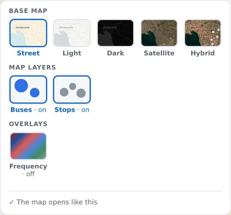
| Option | What it is | When it earns its place |
|---|---|---|
| Street | A full street map, in colour. The one the app opens on | Everyday work |
| Light | The same map, nearly grey | When the overlays are what you are reading and the background should get out of the way |
| Dark | A dark street map | A night shift, or a room with the lights down |
| Satellite | Aerial imagery, hinted Aerial imagery only | Deciding whether a bus can physically make a turn, or whether the "road" is a service lane |
| Hybrid | The same imagery with road and place names over it, hinted Aerial imagery with road and place names | Planning a diversion you then have to describe: imagery shows whether a bus fits, names are what a bulletin and a radio call have to say |
Each preview square is a real piece of that map, of wherever your camera is right now — not a drawing of it. What you see on the tile is what you get.
Satellite and Hybrid appear only where the deployment has been given imagery. That is a licensing decision made by whoever set the deployment up, not a setting of yours; where they are absent there is nothing to switch on.
The credits in the corner
The bottom-right corner carries the map's attribution. It is a licence obligation rather than decoration, and it changes with what you have switched on: the background's own credit is always there, and each overlay adds its own line while it is drawn — because the sources are published under different licences and one credit cannot stand for another. The traffic overlay's licence in particular is not the same as the rest, and Live congestion says what that means for you.
The same corner sometimes carries a Developer handbook link, written for the people who change the software rather than the people who use it. Most controllers will never see it: it is drawn only for accounts that are allowed to open it, which on a normal deployment means administrators. Its absence is not a fault, and it is not where anything in this manual is answered. This manual is the one for you.
What they do not mean
The basemap is not data. Switching it changes nothing about the routes, the stops, the buses or any overlay. It changes what they are drawn over, and nothing else.
A blank background is not an empty map. The background is fetched from an outside map service as you pan, and when that service cannot be reached the background simply stays empty — with nothing on screen saying so — while everything the app draws itself keeps appearing over the blank. Try panning slightly, switch to a different Base map, and check whether anything else on the network is struggling.
Imagery is not current, and the app cannot tell you how old it is. Aerial imagery is flown on somebody else's schedule; nothing on this screen dates it. A lane, a build site or a turn restriction can have changed since. Use it to answer "is there physically room", not "is this what is there today".
Names on Hybrid are drawn at full strength on purpose. Faded labels are unreadable at the zoom a diversion is actually planned at, so they are not softened.
Dark is not just a preference. The app knows which backgrounds are dark and changes the outline it draws around overlay lines so they stay legible on both. That is why an overlay looks slightly different on Dark and on Street without meaning anything different.
Your choice does not stick by itself. The basemap resets to the deployment's own opening choice next time, unless you pin it with the button at the foot of the Layers panel — see Turning overlays on and off. It does travel in a link you copy out of the address bar, so a view you send someone arrives on the background you sent it on.
When it looks wrong
Only three options are offered. This deployment has no imagery configured. Ask whoever administers it; there is nothing to enable from the app.
Satellite is offered and Hybrid is not. The imagery is there and the separate names layer is not. Same answer.
The previews are blank squares. The map service is not answering — the same condition as a blank background, seen in the picker.